skip to main |
skip to sidebar
 Boracay Island is located off the northwest corner of Panay Island, and belongs to the Western Visayas island-group, or Region VI, of the Philippines. The island is approximately seven kilometers long, dog-bone shaped with the narrowest spot being less than one kilometer wide, and has a total land area of 10.32 square kilometers.
South-facing Cagban Beach is located across a small strait from the jetty port at Caticlan on Panay island, and the Cagban jetty port serves as Boracay's main entry and exit point during most of the year. When wind and sea conditions dictate, east-facing Tambisaan Beach serves as an alternative entry and exit point.
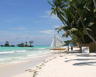
Boracay's two primary tourism beaches, White Beach and Bulabog Beach, are located on opposite sides of the island's narrow central area. White Beach faces westward and Bulabog Beach faces eastward. The island also has several other beaches.
White Beach is the main tourism beach. It is about four kilometers long and is lined with resorts, hotels, lodging houses, restaurants, and other tourism-related businesses. In the central portion, for about two kilometers, there is a footpath known as the Beachfront Path separating the beach itself from the establishments located along it. North and south of the Beachfront Path, beachfront establishments do literally front along the beach itself. Several roads and paths connect the Beachfront Path with Boracay's Main Road, a vehicular road which runs the length of the island. At the extreme northern end of White Beach, a footpath runs around the headland there and connects White Beach with Diniwid Beach.
Bulabog Beach, across the island from White Beach, is a secondary tourism beach and Boracay's main windsurfing and kiteboarding area.
Boracay is divided, for land use and conservation purposes, into 400 hectares of preserved forestland and 628.96 hectares of agricultural Land.
I visited Boracay once and that was an opportunity. I really enjoyed the crystal clear water and the white sands of this place. =)
 ARTISTIC DIVING RESORT is located at the beach front of Punta Ballo, Sipalay City Philippines.

The City of Sipalay established a new concrete road to beach's facilities. It is now a very pleasant access to this Beach Resort. A new restaurant and modern kitchen offers delicious local and international cuisines, even a la carte. Now, they offer an excellent Mongolian Barbecue Buffet for you. Their nice swimming pool invites you for any kind of pleasure and is a great start to learn diving. Apart from diving, snorkeling, eating and relaxing, you can also try beach volleyball, table tennis, or billiard.
 Sulusunset Beach Resort is one of the finest beaches that can be found in the City of Sipalay. This place has 9 Cottages, all are roofed with nipa palm leaves, to have a light any room - perfect for tropical clima.
Getting There
From Manila to Negros:
Sevaral airlines like Cebupacific, Air Philippines and Philippine Airlines have daily flights from Manila to Bacolod and Dumaguete. Take a *Ceres Bus Liner – nonaircon service starts at 2.30am, then every 45 minutes until 8pm and travel time is five hours. Ceres Bus Liner air con service starts at 8am, last trip at 4pm. Travel time is about four hours. *The schedules are subject to change without prior notice.
 LocationThe City of Sipalay is the second to the southernmost town in the province of Negros Occidental . It is bounded by the municipalities of Cauayan in the north, Hinobaan in the south, and Candoni in the east. To its west is the Sulu Sea. The city lies approximately 178 kilometers from the provincial capital of Bacolod City and can be reached via the national road from Bacolod to Hinobaan within 3 to 4 hours.
The City's total land area is 42,770 hectares or 427.7 square kilometers, with a coastline stretching some 45 kilometers long along its western side. Sipalay is politically subdivided into 17 barangays, five of which comprise the poblacion area or the urban core of the City (Barangays 1 to 5). Surrounding the poblacion are the barangays of Nauhang, Gil Montilla, Mambaroto and Maricalum while the barangays of Cabadiangan, Camindangan, Manlucahoc and Nabulao form the hilly to mountainous outskirts. At the northwestern side of the City are the barangays of Cartagena and Canturay, which are traversed by the national road leading to Bacolod . The last barangay at the southwestern portion is Cayhagan, which is linked to the southernmost municipality of Hinobaan via the national road. Barangay San Jose, commonly referred to as the mining town, lies at the upper portion of Gil Montilla east of Canturay and Cartagena. I love Sipalay!


